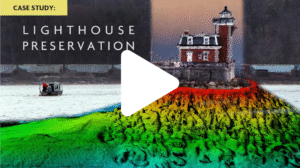
The shoreline’s shifting interface has long defied traditional survey methods. One of Aqua Survey’s specialties is creating engineering-quality 3D models of this transitional zone by merging two high-density data collection methods.
Aqua Survey solves this challenge by combining water-side multibeam sonar with above-water photogrammetric techniques to build precise, engineering-grade 3D models of the transitional zone of your site.
See how Aqua Survey turns the toughest land-water surveys into a desktop-ready reality model. Watch multibeam bathymetry merge with high-resolution photogrammetric data to capture detail on every seawall, pier, and submerged feature with engineering precision.