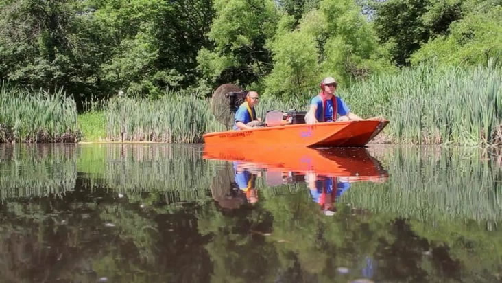
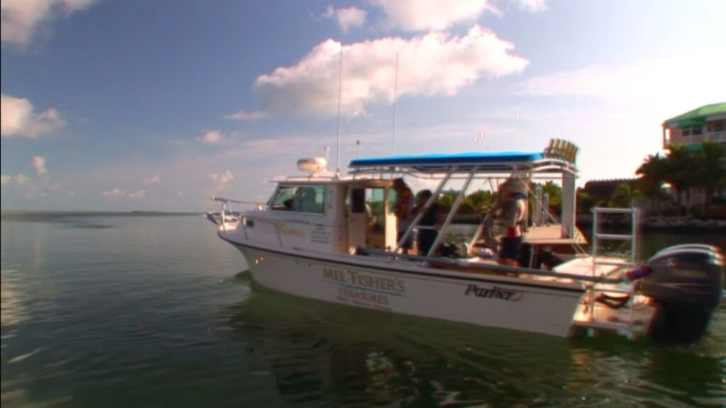
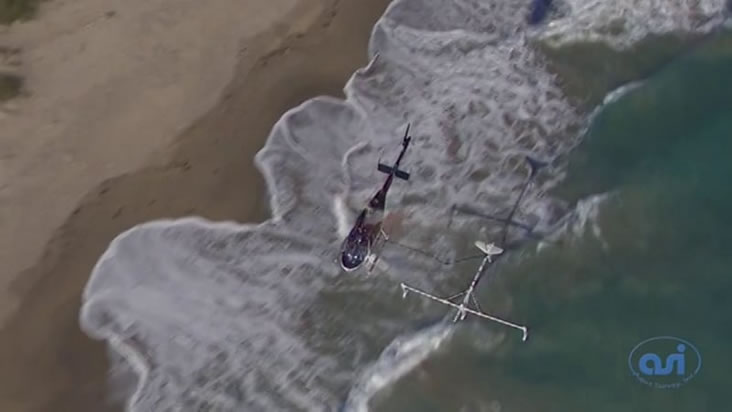
NEWS ARTICLES

Airborne Mag Survey

https://vimeo.com/87183064 When time is of the essence and traditional vessel-towed surveys slow you down, Aqua Survey’s airborne magnetometer glider shifts the paradigm. By cruising just 15 feet above the water at 50–60 mph, it swept nearly 70 square miles in only 20 days—what would have taken years on the water was completed in a fraction of the time. Equipped with a high-sensitivity potassium-vapor magnet gradiometer, the glider maps ferrous anomalies with pinpoint accuracy. From unexploded ordnance and shipwrecks to buried

Read More »

Airboat UXO Survey

https://vimeo.com/43355541 This non-intrusive, floating EM coil survey can map both ferrous and non-ferrous metals. Perfect for lakes and ponds where a below-water engine just won’t do. The Aqua Survey airboat accelerates UXO clearance efforts—protecting communities and unlocking development opportunities in areas previously deemed off-limits.  Watch “Airboat UXO Survey”

Read More »

Aqua Survey Joins SETI & NASA in the High Andes

https://vimeo.com/60078091 In 2012, NASA and the SETI Institute set their sights on Laguna Negra—a high-altitude lake nestled in Chile’s Andes—to simulate conditions analogous to the lakes and seas of other worlds. Battling thin air, frigid nights and rugged terrain, the team conducted systematic water sampling campaigns to assess physical and chemical parameters critical for astrobiology research. Aqua Survey joined the mission as its dedicated laboratory partner, bringing decades of environmental expertise to the High Lakes Expedition. Our ecotoxicology team received

Read More »

BLU-26 Detonation

https://vimeo.com/365124970 During the Vietnam War, Laos became the most heavily bombed country per capita in the world.  To this day there are millions of cluster-bomb sub-munitions littered across its landscape. Each sub-munition, such as the BLU-26 “bombie” used in Laos, is capable of penetrating soil or sediment before detonating—yet a significant percentage fail to explode on impact, becoming unexploded ordnance (UXO) hazards. Villagers—often farmers and children—continue to be injured or killed by unsuspected bomblets. Contaminated land reduces arable acreage, forcing

Read More »

The Atocha Episode 3

https://vimeo.com/2574016 The Atocha Project isn’t just a quest for precious metals—it’s a window into 17th-century Spanish trade, shipbuilding, and maritime life. Every coin recovered tells a story: from the Potosí mints of Bolivia to the European markets they served. Aqua Survey’s precision mapping and detection work not only accelerates treasure recovery but also safeguards historical context, guiding careful excavation that preserves artifacts for science and public display. As the hunt presses on, Aqua Survey remains at the forefront—melding cutting-edge geophysics

Read More »

The Atocha Episode 2

https://vimeo.com/2508948 Aqua Survey’s scientists and engineers designed and deployed submersible, high-powered electromagnetic metal detection systems—capable of scanning the seabed and isolating buried metal targets.  Aqua Survey’s EM-3M 3 meter wide sled is deployed and towed to map large areas of the sea floor, where it is believed the pieces of the wreck could have scattered. When Mel Fisher’s Treasures’ dive and recovery team is splashed to investigate, Aqua Survey helps ensure each dive yields maximum geological and archaeological insight. Watch

Read More »

The Atocha Episode 1

https://vimeo.com/2439476 Few maritime discoveries capture the imagination like the Nuestra Señora de Atocha—a Spanish treasure galleon that succumbed to a 1622 hurricane off the Florida Keys, carrying an estimated $400 million in silver, gold, and precious gems. Centuries later, its manifest still lists 36 coin chests yet to be found, making the Atocha one of the most alluring underwater hunts in history. Aqua Survey has joined forces with Mel Fisher’s Treasures to advance efforts along the Atocha debris trail in

Read More »

Effective Vessel Deployment Options

https://vimeo.com/3850315 Aqua Survey is capable of deploying to your job site through a variety of creative and effective means. When access points to your site are limited, Aqua Survey’s fleet tackles these challenges head-on using crane deployment or small task-specific vessel options from our fleet. Each option is ready to roll—or float—at a moment’s notice, ensuring your project stays on schedule, no matter how challenging the shoreline.  Watch “Effective Vessel Deployment Options”

Read More »

Passaic Multibeam 2014

https://vimeo.com/110145485 Multi-beam bathymetry is an advanced sonar surveying method that collects detailed, three-dimensional maps of underwater terrain by emitting a fan of sound beams beneath a vessel’s hull. Unlike a single-beam fathometer—which ping-pongs one beam straight down—multi-beam spreads dozens to hundreds of beams across a wide swath. This approach delivers: Broader coverage per pass, reducing survey time Enhanced accuracy and resolution for elevation changes and submerged structures High-density point clouds that reveal bedforms, wrecks, utilities, and more Ideal for rivers,

Read More »

UXO Surveys: A Safer Future

https://vimeo.com/3435761 In the United States alone there are over 200,000 submerged acres suspected of containing Unexploded Ordnance (UXO) and Munitions & Explosives of Concern (MEC). These areas are in shallow water zones such as wetlands, freshwater ponds and lakes, estuaries, rivers, coastal bays, tidal flats, ocean shores and coral reefs. As many of the nation’s military bases are closing and being turned over to civilian use, there is a mandate for these areas to be geophysically surveyed to reveal any

Read More »

The Search for the Guggenheims’ Lost Treasure

https://vimeo.com/2827828 Aqua Survey tests its new Electromagnetic or EM metal detection equipment over the Arthur Kill waterway.  Unlike the traditional Magnetometers used for underwater metal detection, underwater EM has the ability to detect nonferrous or non iron-based metals. Aqua Survey puts this new technology to the test in our stomping grounds bordering New York and New Jersey.  Will a treasure lost over a hundred years ago by one of New York’s richest families soon see the light of day?  Watch

Read More »

NASA High Lakes Expedition

In 2007, NASA and the SETI Institute set their sights on Licancabur—a high-altitude lake nestled in the Boliovian Andes—to simulate conditions analogous to the lakes and seas of other worlds. Team conducted systematic water sampling campaigns to assess physical and chemical parameters critical for astrobiology research. Aqua Survey joined the mission as its dedicated laboratory partner, bringing decades of environmental expertise to the High Lakes Expedition. Our ecotoxicology team received hundreds of water samples directly from the field, performing quantitative

Read More »

Trail of the Atocha

https://vimeo.com/5305679 Watch as the Aqua Survey team joins Mel Fisher’s Treasures to continue pinpointing historical artifacts along the Atocha debris trail in Key West, Florida. Aqua Survey employs the new 1 meter diver EM sled to comb the bottom in systematic sweeps. When the sled flags a high-priority signal, Mel Fisher’s divers excavate on the spot—turning invisible clues into tangible treasure finds. Could they be on the heels of a new stockpile of treasure?  Watch “Trail of the Atocha”

Read More »

Guest Luncheon Speaker Dominique Görlitz

https://vimeo.com/9401954 Dr. Domonique Görlitz of the Abora project speaks at the Mid-Atlantic Contaminated Sediment/Soils Symposium: March 24, 2010, Liberty Harbor Restaurant, Jersey City, NJ  Watch “Guest Luncheon Speaker Dominique Görlitz” Learn more about their journey in The Abora III Project

Read More »

The Abora III Project

https://vimeo.com/3202945 The Abora III project was an experimental archaeology expedition led by Dr. Dominique Görlitz. A traditionally constructed craft modeled on ancient reed‐boat designs was completed and departed from New York harbor to test the seaworthiness and navigation methods of prehistoric mariners. Researchers sought to determine whether such vessels could undertake long‐distance sea voyages using only the technologies and materials available to early civilizations. Aqua Survey served as a scientific sponsor for the Abora III Project, supplying harborside assistance, maritime

Read More »